California National Parks of the Sierras - Trip Report - Day 7
Day 7 - Tuesday 6/26 – The Big Hike!
We slept in today…I did not wake up until 0600. Today is the bus ride up to Glacier Point then we’ll hike down the Panorama Trail to Nevada Falls and on to the Valley via the Mist Trail.
Breakfast at the food court; decent blueberry pancakes, but nothing special. We were packed and ready for the bus ride in plenty of time. Busy time at the lodge as there were several tours getting ready to head out this morning; a couple going to Glacier Point and one to Tuolumne Meadows. The first bus heading to Glacier Point was also making the Grand Tour (same one that we did on 2006), but since there were still seats available on that bus, we hopped on it rather than the hiker’s shuttle. This turned out to be a good move as we had an interesting driver and got to see some interesting sights including couple of great animal sightings as we drove through the valley.

Bobcat in Yosemite Valley.

Yearling Black Bear.
|
First, the driver spotted some hang gliders spiraling down from Glacier Point. Seems that hang gliders are allowed to launch from Glacier Point, but only early in the morning and they have to land in one specific meadow in the valley.
The first animal encounter was one of the top highlights for the trip, particularly for Lynn, as we saw a Bobcat just jogging along the trail parallel to the road. I got a couple of decent shots from the bus (fortunately the back of the bus where we were sitting was almost empty, so I was able to move around to get a good angle. It was definitely a boy kitty, as we saw him spraying the shrubs as he passed. The cat seemed completely indifferent to the action on the road, as the bus had slowed for better viewing but several cars kept speeding by.
Shortly after the bobcat, someone spotted a bear on the same trail. The driver indicated that this was a yearling bear as it was not that large.
We also spotted a mule deer buck right alongside the road. These three instances really illustrate the point of paying attention on the park roads, as any of these critters could have dashed out in the road at any time. Death by automobile is a leading cause of wildlife mortality in the parks. For example, I’ve read that in Yellowstone there is an average of one mega fauna kill on the roads each day. That’s bad for the animal but can also cause injury or even be fatal to the folks in the car.
It was a pleasant drive up to Glacier Point. Nice to have someone else do the driving. Our driver, Bill, also provided some history of the park and the area in general and pointed out some of the interesting features along the way.
|
He talked about how the wind in the valley will often blows the water from Bridal Veil Falls back up into the air. The Native Americas thought the area was inhabited by evil spirits that would steal your breath. The spirit was called Pohono, and the falls were also originally known by this name. A friendlier name was sought to bring more visitors to the parks, and the name Bridal Veil was selected based on the resemblance of the falls to the flowing lace of a bride’s veil.
Bill also talked about the name given to the park and how there are several versions, but that one of the more common themes deals with a fearsome tribe of Native Americans that lived in the valley and were known for their ability to hunt grizzly bears. Yosemite literally means “those who kill.” He also mentioned that the Native Americans who lived here called the valley Awooni which means “large mouth” in reference to the appearance of the valley from their village located in the valley. One of the white settlers, a man named Bunnell who dealt with the Indians, set the spelling as Ahwahnee.
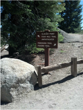
I guess we're heading to the right!
|
The bus arrived at Glacier Point at 10:10. We hit the restroom before hitting the trail. Note that the main restroom facility building (nearest to the trails and the overlooks) is closed due to water problems, but there are 3 or 4 other outhouses located along the walk adjacent to the parking lot. If you want to avoid long lines for the restroom, walk to the facility at the far end of the parking lot (away from Glacier Point); there are two very nice outhouses and generally no lines.
I reckon we were on the trail about 10:30. We saw a mule deer near the beginning of the hike. That would have made a nice shot with Half Dome in the background, but the deer was camera shy and she kept her head down and soon moved out of sight. Oh well. We saw a googolplex of ground squirrels and a few lizards along the trail and a few birds, but mostly this hike was about the scenery and the views.
This is really the tail of two trails, first from Glacier Point to the top of Nevada Falls along the Panorama Trail, then from Nevada Falls to Happy Isles via the Mist Trail. While the entire hike from Glacier Point back to the valley was tremendous and extremely scenic, the character of the two trails was very different.
|
|
The Panorama Trail is generally a dirt trail and fairly wide with scattered patches of rocks and roots. The character of the immediate surroundings along the trail changes as you work your way down from Glacier Point. At the top of the trail, the views are very open as you are going through meadows and some areas of burn forest, but the further down the trail you travel the more forested the trek becomes. However, the views are also outstanding for the length of the hike. Half Dome and some of the other prominent features are seen all along the trail, there are great views over Clark’s Range early in the hike, and you get to see Illiouette Falls. There were also some nice areas of wildflowers when we made the hike.
We also found the short spur trail to Panorama Point. That was well worth the detour. There is an outstanding view of the valley from this vantage point. There are no railings at the overlook (you can see where the railings used to be installed), so do be careful. Panorama Point also provides a good place to look back to the opposite hillside and view the trail that you just traversed.
The last part of the trail, as you are working down to the falls and near the intersection with the John Muir Trail, was a bit wet, and this was a dry year. I just wonder about the trail condition along this stretch in a wet year.
We met a lot of folks on the Panorama Trail, and shared some pleasantries and jokes with several of our fellow hikers. So no issues at all as we hiked down from Glacier Point to the Top of Nevada Falls. The only thing that was a little concerning was the amount of litter on the trail. It’s not like there is tons of garbage along the trail, there isn’t; however, there was more than I would have expected (mostly paper and Kleenex, but no bottles, cans or wrappers that I saw).
|

Lynn marching down the Panorama Trail.

Taking a break. Half Dome is in the background.
|
I must say that I was a bit surprised by the scene at the top of Nevada Falls. It seemed more like a beach party than a hike in Yosemite. There were folks scattered all along the creek bank sunbathing and several folks wading in the pools above the bridge. We later passed folks coming up the Mist Trail who looked like they were heading to a beach party; carrying coolers, wearing swimsuits, including bikini tops, and a few even with flip flops (really not the appropriate footwear for that trail; most did have on hiking shoes or boots).
While the hike from Glacier Point to Nevada Falls was a very pleasant trail, the hike down the Mist Trail to Happy Isles was a killer! And for a number of reasons. Now don’t get me wrong, it is a great hike and extremely scenic with excellent views of Nevada and Vernal Falls, the creek that feeds the falls and the surrounding canyon. However the trail is difficult. Some of the guide books that I read list the Mist Trail as “moderate” but I think “strenuous” is a much better description. The trail itself is very steep, very rocky, mostly steps and the steps are not evenly spaced. That said, I know this is still a marvel of the park service and hats off to the folks in the CCC that built this and other trails throughout the parks system. But still, I was not quite prepared for the change in the character of the trail after the relatively easy hike down the Panorama Trail. My fault for not doing a better job of researching the hike, but the references that I did peruse did not adequately describe the Mist Trail, IMO. Perhaps we should have come down the John Muir Trail. I know that it is steep as well, but perhaps it is not as steep as the Mist Trail.

Half Dome (left) and Liberty Cap (right); Mount Broderick is obscured by the trees in the middle.
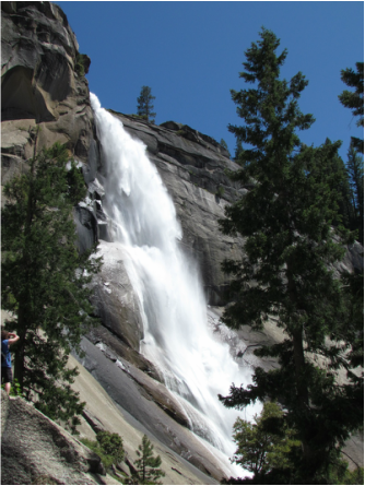
Nevada Fall.
|
The Mist Trail was also very busy as folks were heading up to and down from the falls (many were heading to the beach parties above both Nevada and Vernal falls). Most folks on the trails were polite and willing to share the road, but there were a few that were approaching rude in terms of passing or not waiting their turn. And it is not like we don’t pull over and let the faster traffic pass us; we make a habit of that since we tend to take our time on the trails. It just seemed like a higher occurrence of rudeness on the trails compared to my experiences in southern Utah, Glacier, Yellowstone or Grand Teton. Still there were many more friendly and helpful folks on the trials, so rudeness was the exception, but it was noticeable. And my observation was that these were the younger folks on the trails (the 20-somethings), just like the impatient young women at Moro Rock. Hopefully they’ll figure it and mellow a bit with age. There were also more folks who seemed unprepared for the hike along the Mist Trail; improper footwear, no hat, no water; again the exception but still noticeable.
The other thing that I noticed was a complete lack of regard for the posted signs above Vernal Falls indicating that both the Emerald Pool and the Silver Apron above the falls were closed areas. I bet there were two dozen people out on the apron an in the pool, and there were more wading through the creek just above the falls to get to the pool. Shoot, I saw kids on the far side of Emerald Pool and at least one toddler with her parents wading along the edge of the pool (on the far side of the pool, so they had to cross the creek to get there). C’mon folks, the rules are there for a reason and when you risk your life and the gamble goes bad, then you are putting others at risk when they come to your rescue (remember the flags at half-staff in Sequoia?). OK, I’ll get off my soapbox.
Still, overall it was a great day and a nice hike. I guess we were off the trail around 4:30 or 5:00. We caught the shuttle at Happy Isles back to Yosemite Lodge. After getting cleaned up, it was back to the lounge for a beer and dinner. We were back in the room and in bed by 8:00 and lights out was at 9:00. Nine miles of hiking will do that to you! As usual, I drafted a review of the hike on both Trip Advisor and EveryTrail (the verbiage is about the same, but there is the trail map on ET, also shown below) and there are additional photos from the days trek.
|
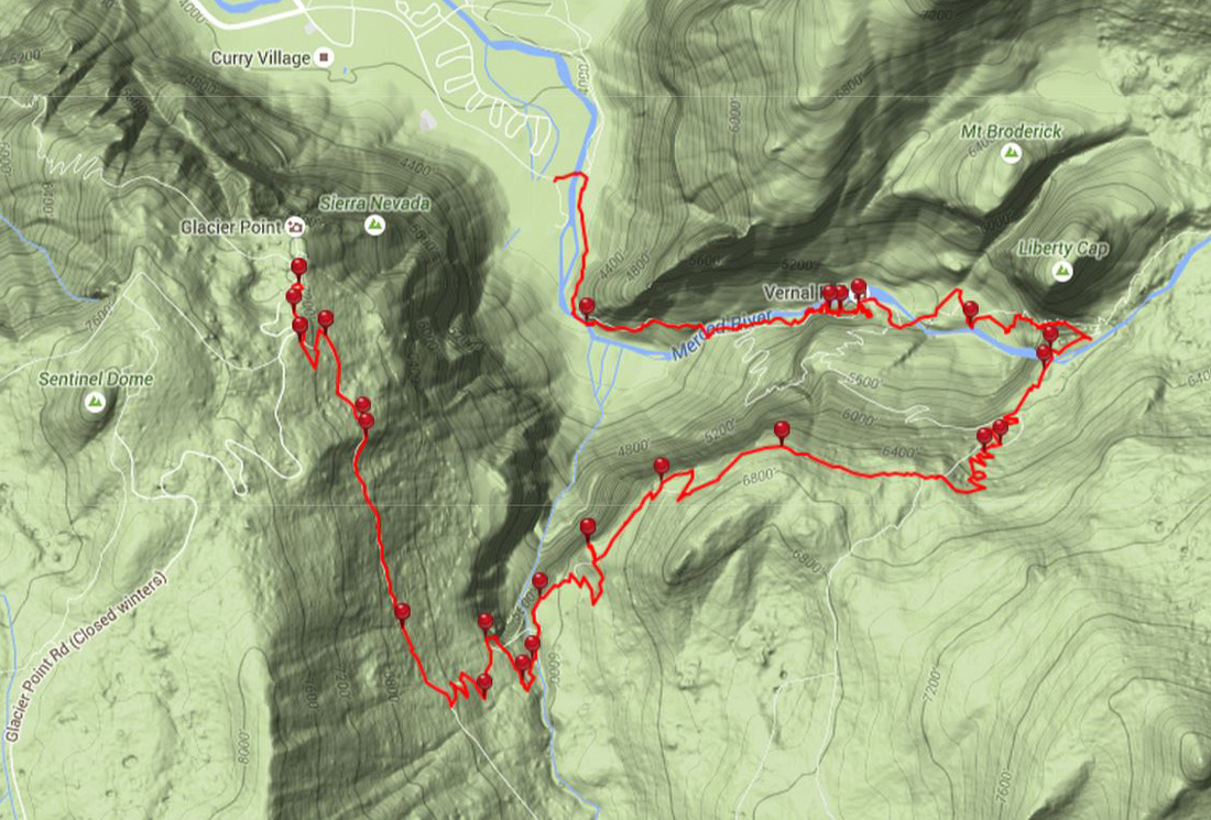
Track of our hike from Glacier Point to Happy Isles taken from EveryTrail.
Skip to: Days 1 and 2 - Day 3 - Day 4 - Day 5 - Day 6 - Day 7 - Day 8 - Day 9 - Days 10 through 13.
Return to:
California 2012 Trip Report Intro Page.
We went there in... 2012.
Travel Timeline.
Trip Report list.
Return to:
California 2012 Trip Report Intro Page.
We went there in... 2012.
Travel Timeline.
Trip Report list.