California National Parks of the Sierras - Trip Report - Day 6
Day 6 - Monday 6/25 – Glacier Point
Up early again but trying to be as quiet as church mice to avoid waking our neighbors. I think the thin walls are Wawona are the only real drawback to this historic hotel. Lynn spied a turkey hen strolling through the front yard this morning, so our theme of seeing wildlife from our room continues. We got cleaned up but in an effort to be quiet we just worked puzzles for a bit before heading to breakfast at 7:00. The continental breakfast buffet was included in the room rate. The buffet was a little sparse on content, but was sufficient to start the day.
|
So I decided to get in 9-holes, provided that I can get out right away and have a quick round, then we will head to Glacier Point as we transfer our base to Yosemite Valley. I checked in at the golf course when it opened at 8:00; no issues with getting out. In fact, I was the second player out for the day (the first guy was walking to number 1 tee when I was entering the club house). I had to buy or rent everything (clubs, pull cart, ball, tees…the works, plus greens fees to walk nine holes came to $68.00). I reckon I got to the number one tee about 8:20 and was back in the clubhouse by 9:45.
It is a very nice course, with a good variety of holes. It is only a nine-hole layout, but there are two sets of tees to make an 18-hole track. The first couple of holes are out in the open, but then the character of the course becomes more tree-lined. There is some elevation change with a few of the holes, some uphill, some down. Plus is it a very scenic track. Saw a few critters (mule deer, squirrels and several birds) and heard a few others (the thumping call of the Blue Grouse).
|

View from the tee of number 6, a tough par 3.
|
Very playable track, particularly if you hit the ball straight (yeah, aren’t they all!). A few holes require decent length off the tee, but it is not a course that you have to try to overpower. I played pretty well at times and shot about bogey golf. Here’s my review.
Lynn met me at the golf shop; she was sitting out on the lawn reading and enjoying the morning. I bought a Wawona shirt, then we headed back to the room to finish packing. On the road about 10:15 with a quick stop at the General Store for snacks. Here are the reviews for Wawona lodging and dining. Next stop Glacier Point.
A very easy drive from Wawona to Glacier Point; about an hour total. The parking at the Sentinel Dome trailhead was jammed when we passed by with cars lining the road for probably a quarter mile in each direction…obviously a popular hike. There are some lovely views along the road, particularly to the south, plus there are good opportunities for animal sightings just about everywhere. The meadows are particularly promising, although we did not see any in those areas this trip.
The road has some bend to it for its entire length, but is not extremely winding until the last mile or so as you work your way down to the viewpoints at Washburn and Glacier Points. The drive-by view of Half Dome from Washburn Point was amazing. You round a bend in the road and there’s Half Dome just dominating the vista. It is truly an impressive sight. We’ll stop here on for a better look on the outbound trip. We were snapping photos at Glacier Point at 11:15.
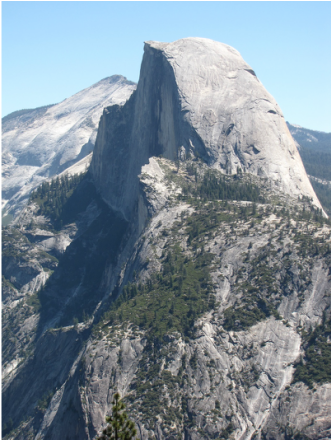
Lynn took this portrait of Half Dome.
|
The views from Glacier Point are beyond belief. I was concerned that the views might be a bit muted due to smoke from the fires in the area or haze from the coast, but that was not the case. In fact, I believe that the views were actually clearer than when we visited in June 2006. I think we got some very good shots of the granite monoliths and the waterfalls. Yosemite Falls was a mere trickle compared to last trip. We enjoyed the views all along the trail and at each of the overlooks, including the Geology Hut. There are a few very cheeky ground squirrels in the area…obviously these guys were not aware of the “do not feed the wildlife” rules. We also saw a Peregrine Falcon soaring along the cliff face below us...kinda cool. The vistas in all directions were amazing. We could see folks floating down the Merced River on green rafts…lots of rafters.
We located the Panorama Trailhead (you can’t miss it; right on the way from the parking lot to the vista points), so we were all set for our hike tomorrow. We also reconnoitered the snack/gift shop at Glacier Point; decent selection, but we’ll probably get our supplies for hiking from the store in the Valley as there will certainly be more options there.
|
After soaking in the views at Glacier Point, we retraced our route to Wahsburn Point and made a short stop. Equally impressive views. The focal point at this vantage point is Half Dome along with Nevada and Vernal Falls. Washburn Point also provides a good overview of the western range. These vantage points absolutely provide the “big picture” perspective.
|
Then we headed back down the hill to the Sentinel Dome Trailhead. Boy did we get lucky with the parking. As we were coming down the road, a car was pulling out of the parking lot; either someone who pulled through because they could not find a spot, or someone leaving to make room for us. Fortunately, it was the latter and we got the only spot open in the lot (just like my golf game, I would rather be lucky that good!). Otherwise we would have been looking for some place along the side of the road into which to wedge the rental car. The point of the story is to get an early start to beat the crowds so that you don’t have to rely on luck for getting a place to park. Anyway, I reckon we were on the trail just a little past noon.
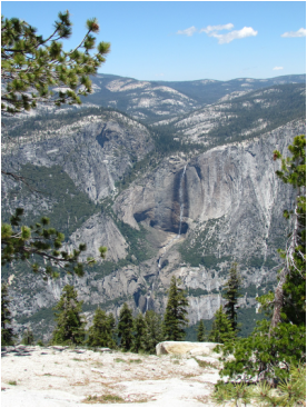
Yosemite Falls as seen from Sentinel Dome.

Lynn on top of Sentinel Dome.
|

Profile view of Half Dome from Washburn Point.
We opted for Sentinel Dome first as that was primary point that I wanted to hit (since we have a longer and more strenuous hike planned for tomorrow, I figured I would let Lynn dictate how much hiking we would do today). Lynn did nix the idea of making a loop between Sentinel Dome and Taft Point by using the Pohono Trail as a connector; her theory was that there would be more elevation change on the Pohono Trail since it looks like it goes into a small valley between Sentinel Dome and Taft Point.
It was another beautiful day for hiking; sunny, blue skies with a few puffy, white clouds, but a little cool, around 60 degrees F with some wind at times, particularly going up the dome (hang on to your hats!). The trail to Sentinel Dome is in good shape, although it is rocky and had exposed roots in places, so watch the trip hazards. It is also not a very wide trail until you get to the exposed rock of the dome, then there is plenty of room. The trail is well marked.
It is also a pretty hike to the dome through a forested area, but you get glimpses of the valley as well as Sentinel Dome from the trail. From the parking situation, we knew that it would be a popular trail, and it was, but since there are two destinations from the one trailhead (Sentinel Dome and Taft Point), neither trail was really that crowded.
As you near Sentinel Dome, you can see folks on the summit; by the size of the people, the dome is taller than it looks. The trail wraps around the dome before making the final climb to the top. You basically have Half Dome to your back as you are climbing up Sentinel Dome, so whenever you need a breather, just stop, turn around and take in the view…of course, the view also takes your breath away!
We saw two more mule deer bucks at the base of the dome, a few Ravens and of course ground squirrels. But the real reason to make the hike are the views; 360 degrees from the top of the dome and awe-inspiring in every direction. Half Dome and the views into Yosemite Valley dominate to the east and north and west, but the views across the back country to the southeast and south are also marvelous. It is only a 2.2 mile round-trip to Sentinel Dome and an easy to moderate hike on a good trail, so this really is a great short hike to a super vantage point.
|
|
There seemed to be a little more traffic on the return trip, but still not too bad. We made time to enjoy the wildflowers and butterflies along the trail, as well as the views. Again, there are some narrow places in the trail that require one-lane traffic, so we would just find a wide spot in the trail and let the oncoming folks pass.
Once back at the trailhead, we just continued on toward Taft Point. The character of the trail is different than the trail to Sentinel Dome. The Taft Point Trail is wider and generally smoother (a few rocky or exposed root areas, but general a flatter trail surface). There is one creek to negotiate, but there were rocks arrayed across that allow for an easy and dry crossing. Probably 0.8 of the 1.1 miles to Taft Point is this dirt trail through the woods. Lots of wildflowers along this trail as well. We saw a couple patches of snow plants…their bright red petals make them hard to miss.
Once out of the trees, there is a stretch where the trail is rocky and rooted, but well marked. You work down a couple of short switchbacks to the granite plane that ends at Taft point. The trail here is bordered with rocks so that you know where the trail is located. For safety sake, make sure to stay on the trail as you pass by the fissures. There are well parked side trails that allow you access to the vantage points looking into the fissures as well as the valley. The fissures are pretty cool…just don’t get too close!
|
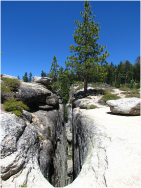
One of the fissures on the way to Taft Point.
|
There are more spectacular views from Taft Point. There is one small section along the edge that has a railing for a relatively safe viewing platform. Good thing, as otherwise I would have to stand back too far to see down into the valley (I don’t like exposed edges with steep drops, but if there is a railing or fence to stand behind, then I have no problems, well, minimal problems, with peering over the edge).

The view from Taft Point. El Capitan is the "big rock" to the left.
Overall this is a 4.25 mile hike (at least according to my GPS; the trail guides have it as 4.4 miles), and it took us just under 3 hours, but we do a lot of stopping and gawking and take a lot of pictures on the trail. I reckon we were back at the trailhead a little after 3:00. Still crowded, but a few parking spots were open in the lot by now. Time to head to the Valley and check in at the Lodge. Here’s my trail map from EveryTrail, and the review I posted on Trip Advisor.

|
We were only on the road a few minutes when something big and furry ambled out into the road about 30 yards in front of us: a coyote. He seemed bigger than the coyotes we have in Ohio. He walked across our lane and in front of the SUV stopped in the on-coming lane, paused a moment, then turned and starting walking toward our car then down the side of the road. Lynn was able to get a nice photo of the big canine from the passenger window. You just never know what you are going to see when you drive through the parks….and more is yet to come! You also have to pay attention as you drive, for the same reason; you never know what is going to run out in front of you.
|
On the entrance into the valley, we stopped at the Tunnel View overlook. Lovely view down the valley. Bridal Veil Falls was puny compared to when we viewed in last in 2006 and Ribbon Falls was completely dry. I know that this past winter was very light on snow, so the snow fed waterfalls are drying up, but I wonder if the winter of 2005-06 was a particularly heavy snowfall year? I did a little searching on the web but only came up with anecdotal evidence that indicated there was a lot of snow during the winter of 2005-06. Still a very pretty view, even if the waterfalls are not flowing.

Looking up Yosemite Valley from Tunnel View.
We arrived at the lodge at 4:30. Check-in was easy…much easier than making the reservations! We also picked up our tickets for the 8:30 AM hiker’s shuttle to Glacier Point for tomorrow. We were in the room by 5:00, after once again getting lucky with finding a parking spot. Man, this place was a mad house. Plus some yahoo had parked their truck and trailer in the lot taking up about a half dozen slots, but I think that rig was about to get towed…but I digress. Back to the room and what a room! We were told that that we got one of the newly refurbished “green” rooms in the Tamarack Building (room 4122). This was a handicap accessible room with a king bed (not that we needed the ADA setup, but it made for a nice layout). The room was quite large and comfortable. Amenities included a refrigerator and hair dryer, but no coffee maker. The inclusion of the fridge and exclusion of the coffee maker were both for bear awareness. To make up for the lack of the coffee maker, we were given coupons for coffee at the food court. Between Wuksachi and this refurbished room in the Lodge at the Falls, we stayed at two of the nicest and newest lodges in the National Park system.
Oh, yeah, the reservations. That is a chapter in this book unto itself. I’m not a National Park rookie, so I knew that I needed to make reservations well in advance. As it turns out, reservations open a year and a day in advance of the arrival date, so I had my calendar marked with reminders. No problem getting the Wuksachi reservations. I called on the prescribed day, but not immediately when the reservation lines opened and still got the dates that I wanted. Perhaps that lulled me to sleep a bit when it came time to make reservations at the Lodge at the Falls. I made the call on the day reservations opened, but waited a couple of hours. Mistake. When I called, I got straight through, and was told that the hotel was fully booked! Fascinating. The young lady I talked to said that the reservations for the Lodge at the Falls usually sell out within an hour. Wow, that caught be a bit by surprise. I know there are other things that sell out that quick (like Phantom Ranch at Grand Canyon or Sperry Chalet at Glacier), but I thought that there was a little more leeway on the Lodge at the Falls. The agent gave me the run down on available properties, and since the Wawona was available I grabbed a room there for the four nights that we wanted in Yosemite. I got a little more insight on reservations from the agent. She said to be on the line as soon as the office opened at 0700 west coast time. That became the plan for the next day. Alarms set. I had two phones and Lynn had one and we dialed in and waited. Lynn finally got through after about 45 minutes. The agent she talked to said we got the last available room. Any port in a storm at this point. We booked 4 nights at the Lodge at the Falls, and kept one at Wawona, so in the end the trip ended up being a day longer, so while the reservation process is a pain, it all worked out in the end. An interesting side note is that the agent suggested using the on-line reservation system (this is also suggested during the recorded message while on hold with the reservation line), however the problem with this is that the website had slowed to a crawl during the high traffic times, making it virtually useless.
|
Once we unloaded and settled into the room, we headed over to the lounge for a drink and just ended up having dinner there. We tried one of the local brews, the Tuolumne Meadows IPA from Mammoth Lakes. Excellent! We got some chips and salsa to start, then finally ordered dinner (we were still debating going to the restaurant, but the longer we sat the more our ambition waned). I had the chili which was just OK. Lynn had the lasagna which she liked. We split a piece of pecan pie; also good but not great. But still a good place for a light meal and a beer plus it was not crowded at all. We’ll be back.
|

|
We stopped at the general store for trail snacks. But there were no golf shirts for sale. One of the staff suggested that we look at the store in the village since it is larger and has a wider variety of merchandise; something for another day. I did have to make a return trip to the store for beer so that we could take advantage of our patio. A nice and relaxed way to end the day. I spent the time catching up on my notes and looking at the photos from today…here’s a sample of the highlights.
Skip to: Days 1 and 2 - Day 3 - Day 4 - Day 5 - Day 6 - Day 7 - Day 8 - Day 9 - Days 10 through 13.
Return to:
California 2012 Trip Report Intro Page.
We went there in... 2012.
Travel Timeline.
Trip Report list.
Return to:
California 2012 Trip Report Intro Page.
We went there in... 2012.
Travel Timeline.
Trip Report list.